In August you still find snowfields in the Snowy Range of Southern Wyoming. I found the Snowy Range – the Snowies -- in June taking a detour enroute to the American Society of Safety Engineers’ (ASSE) Safety 2017 national conference and expo in Denver. The Snowy Range runs through Medicine Bow National Forest, about 30 miles west of Laramie, Wyoming and 161 miles northwest of Denver. The closest town is Centennial, population 270, with one gas pump and one ATM.
Five years ago, after the ASSE Safety 2012, also in Denver, I detoured on the way home to hike the Badlands in South Dakota, where I wandered off a trail, lost my grip on crumbling sandstone, and fell head over heels down a small ravine. They had to chopper me out, wrapped in aluminum foil, to a hospital in Rapid City. My pelvis was broken two places and my bruised and swollen face looked like a Halloween mask.
Back again
So here I was again, roughing it, if you can call it that, really in a tame way (a hotel bed every night) on my own. On a blazing bright and crisp Sunday morning, I hopped in my rental and drove west through the forest on paved WYO-130, parts of which are gated shut from November to May, not knowing exactly what I’d find or where I’d end up. I knew nothing of the Snowy Range until I laid eyes on it right off 130 early that morning.
When you get hurt on the job in a fairly serious way (say a broken pelvis and a couple of months before you can walk again), what do you do differently when you return to work? After I pulled my rental off the road and started walking atop a snowfield maybe a foot deep toward Sugarloaf Mountain (elevation 11,398 feet) the thought crossed my mind: OK, what the hell did I learn in the Badlands? Sugarloaf Mountain is above the tree line, topped by a gray dome-shaped pile of boulders and rocks. A mountain guide blog says it’s a short Class 2 scramble to the top. Class 2 is defined as “simple scrambling with possible use of the hands.” Scrambling is somewhere between hiking and mountaineering, following no defined or waymarked path, to a non-technical summit – one reached without the need for climbing equipment such as a body harness, rope and protection hardware.
Learning the hard way
Sugarloaf Mountain is a non-technical summit. So I could scramble up it without PPE. Hiking boots are highly recommended for Class 2 scrambles and I had them – in the Badlands I was wearing running shoes. That’s one mistake I wouldn’t make again.
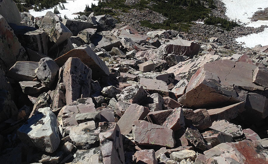
Sugarloaf’s boulders and rocks – red, black, chalky white and gray – are made of granite. Literally sharp-edged hard rock. It wouldn’t crumble in my grip like the sandstone in the Badlands. A firm, solid grip is something else I learned from my accident. I need it; won’t scramble or climb anywhere without it.
A third lesson taken from my Badlands fall was never go off the trail. But there is no trail on the western face of Sugarloaf. So do I turn around and go back to my car? It was a beautiful cloudless morning, in some of the cleanest air in the United States. It wasn’t a day for driving around; it was a day for being out and about. The non-technical summit didn’t appear too intimidating, maybe a 400-foot scramble to the top. I’d give it a go.
Another thing I learned from my accident is to know my limits, know when to turn back before the ascent becomes too steep, too unstable, too difficult, or if bad weather is approaching. Before that accident I never thought about the idea of limits. I was complacent and didn’t have a clue.
Post-accident, it’s all about mindfulness. I’m much more cognizant of my limits, my grip, my footing, my surroundings. The scramble up Sugarloaf was like climbing stairs, moving from rock to boulder, boulder to rock. I very much needed my hands, despite the definition of Class 2 scrambling. I enjoy the combo of “skills” for climbing and hiking – I use “skills” loosely, possessing a low-grade, non-technical set of these assets – which call for mindfulness; alertness; focus; concentration; a type of strategic thinking that’s like playing chess, figuring out your next move, which rock has the best footing, which path or angle looks the safest to the top. Climbing and hiking also tests your balance, flexibility, arm and leg strength, and stamina.
It took maybe an hour to crawl, slither, slide and jump across the quartz rocks and brush to reach Sugarloaf’s windblown summit. The view was stunning: the Snowy Range (a friend saw a Facebook photo and thought it was Iceland), Medicine Bow Peak (elevation 12,013 feet), shimmering Mirror Lake, WYO-130 curving through the mountains and meadows, and far off in the distance Colorado to the south, the Wyoming plains to the east.
The voice of experience?
Another lesson learned: don’t buy into what more experienced voices have to say, especially if they’re the competitive macho breed. Mountaineering bloggers call Sugarloaf “a quick, fun diversion” and “one of the easiest” mountains in Wyoming above 11,000 feet high. “The peak isn’t too rugged. All routes require (supposedly hands-free) scrambling.”
All I know is when I got back to Denver and spent several days walking the Colorado Convention Center my cramped, stiff, aching legs felt like they were exploding, as though I had walked the 1,700 miles from my home in Philadelphia to the meeting. Sure, after an accident you can get back on the horse, go back on the job. Nothing says it’s going to be easy. Or any safer. It’s up to you and what you’ve learned.


